YADKIN PEE-DEE RIVER BASIN

Image: Christine Rucker Photography
Only 1% of the earth’s water is available fresh water. The Yadkin Pee Dee River Basin is North Carolina’s second largest basin, including 5,862 stream miles and 22,988 lake acres, and spanning 21 counties and 93 municipalities. It is the principal source of water for the central Carolina region; however, it is threatened by industrial pollution and poor management. Yadkin Riverkeeper promotes, protects, and advocates for the river and the communities that depend on it.
The Yadkin Pee Dee River Basin covers more than 7,200 square miles of the Carolinas.
The current population within the Yadkin Pee Dee River basin is about 1.6 million people in North Carolina, with an average population density of 222 persons per square mile.
The Yadkin River serves as the drinking water supply for over 841,000 people.
Approximately half of the watershed is forestland, most of which is privately owned. Nearly one-third of the watershed is used for agriculture, including cropland (15.6 percent) and pastureland (14.1 percent). Just 13 percent of the land is developed, although this figure is rising rapidly.
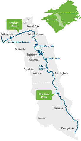
The Yadkin Pee Dee River Basin bisects North Carolina, running north to south. From its headwaters near Blowing Rock, the Yadkin River flows east and then south across North Carolina’s densely populated midsection. It travels 203 miles — passing farmland; draining the urban landscapes of Winston-Salem, Statesville, Lexington and Salisbury; and fanning through seven man-made reservoirs before its name changes to the Pee Dee River below Lake Tillery.
The Pee Dee travels another 230 miles to the Atlantic, leaving North Carolina near McFarlan and ending its journey at Winyah Bay in South Carolina.
The Mitchell, Ararat, Uwharrie and Rocky Rivers and Dutchmans, Long and Abbotts creeks are major tributaries of the River. The uppermost reservoir is W. Kerr Scott Reservoir. The Yadkin chain of lakes is comprised of six reservoirs: High Rock, Tuckertown, Badin (Narrows), Falls, Tillery and Blewett Falls. They were built in the first half of the 20th century to power Alcoa’s (now Cube Hydro’s) aluminum smelters and Duke Energy’s electric utilities.
High Rock is the first and largest of the Yadkin chain lakes. Badin, the oldest, was built in 1917 just below the gorge called “the Narrows” to power an aluminum plant in Badin. Badin Lake has been described as a bassmaster’s paradise and the place to find largemouth.
Forests cover half of the basin, including the federal lands of the Pee Dee National Wildlife Refuge, the Blue Ridge Parkway and the Uwharrie National Forest, which lies completely within the basin.
Since it originates in the Blue Ridge and drains portions of the Piedmont, Sandhills and Coastal Plain, the Yadkin Pee Dee River Basin contains a wide variety of habitat types, as well as rare plants and animals. The basin’s rare species (including endangered, threatened, significantly rare or of special concern) include 38 aquatic animals. Two species are federally listed as endangered — the shortnose sturgeon, a migratory marine fish that once spawned in the river but has not been spotted in the basin since 1985; and the Carolina heelsplitter, a mussel now known from only nine populations in the world, including the lower basin’s Goose Creek. Five new species, all mollusks, have been added to the state’s endangered species list — the Carolina creekshell, brook floater, Atlantic pigtoe, yellow lampmussel and savannah lilliput.
THREATS
Yadkin Riverkeeper works to address threats to the river posed by long-term chemical contamination, coal ash storage, extreme weather events, climate change and sprawl, while redoubling our efforts to protect the Yadkin River’s vulnerable floodplains, tributaries and river access points.
We are working to increase our capacity to monitor and respond to other threats to the river and lake systems, particularly posed by plastic trash, algae blooms, large-scale animal production in the basin and increased recreational use as the population grows.
Sources: Yadkin Riverkeeper; N.C. Office of Environmental Education http://www.eenorthcarolina.org