by Bailey R. Hill, Environmental Justice Advocate
Our StoryMap is live! After much anticipation and preparation, Yadkin Riverkeeper’s interactive environmental justice site is now accessible to the public.
Visit our StoryMap here: Examining Environmental Injustice in the Yadkin River Basin

Yadkin Riverkeeper hosted two environmental justice-related events leading up to the release of this StoryMap:
1.) The Smell of Money, documentary screening at Aperture Cinema in Downtown Winston-Salem on June 8th
2.) StoryMap preview and panel discussion at the Center for Design Innovation on June 9th.
The purpose of our presentation on June 9th was to gather feedback from community members about the current structure of our data visualization, to amplify the voices of local environmental activists, and to build camaraderie within the Yadkin Watershed as we partner with environmental justice communities.

Bailey and Grace present a preview of YRK’s EJ StoryMap at the Center for Design Innovation on June 9, 2023.

Community Activist panel discussion moderated by Bailey (left) and Grace (right).
Special thanks to our panelists:
Crystal T. Dixon, MPH, MA
Associate Professor of Health and Exercise Science at WFU
Founder, Mango Consulting
Anakha Anet
Grassroots Civic Engagement Coordinator at Island CultureZ & BBRRAAPP (Black & Brown Radical RootZ Agricultural Arts Political Party)
Jerelyn Travick
Resident Leader with Neighbors for Better Neighborhoods (Northwood Estates Neighborhood Association)
Chenita Barber Johnson
Local Author (African American Firsts of Winston-Salem / Forsyth County North Carolina: Pioneers who greatly impacted this city, this county, this nation and the world)
Resident Leader with Neighbors for Better Neighborhoods (North Winston Neighborhood Association)
Member of the Coalition 4 Accountability and Transparency
StoryMap Highlights
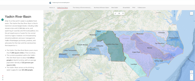
Our StoryMap begins with an introduction to the study area: the Yadkin River Basin. We first offer an explanation of how water flows within a watershed throughout the larger river basin. This section provides context for our research so that residents who visit the site will have a better understanding of pollution impacts on water and surrounding communities.
Within this section of the StoryMap, we provide a closer look at the socioeconomic disparities within the Yadkin River Basin. Using ACS (American Community Survey) data at the census tract level, we have mapped the location of high-poverty areas and areas with a higher concentration of People of Color. This data visualization allows us to concentrate on the intersectional demographics of Race and poverty when evaluating environmental disparities in water quality.

In the following section, we explain the environmental justice movement by highlighting the work of Robert Bullard and the significance of protests in Warren County, North Carolina. which led to greater awareness of environmental disparities among low-income households and Communities of Color across the nation.
Image courtesy of Upstream Solutions

In the sections containing community highlights, we include timelines of key events that have affected local waterways, leading to environmental concerns among residents.
Our advocacy for environmental justice is modeled after three strands of justice outlined by Rowangould et al. (2016)[1]:
distributional justice, which ensures that “no community is over-burdened by environmental hazards and that all have access to environmental benefits,”
procedural justice, which ensures that “those suffering from environmental injustices have a meaningful voice in shaping public policy and corporate actions,” and
recognition, which ensures that “diverse kinds of knowledge are considered legitimate when shaping policies and plans.”


As we continue to engage and advocate with residents of West Badin and Northeast Winston-Salem, we plan to edit the StoryMap to reflect key updates regarding grassroots organizing, policy initiatives, resident testimonials, and changes in data.
In the final analysis portion of the StoryMap, we have compiled data for the location of brownfields in relation to ACS poverty and race datasets. The image below is a screenshot of that section.

It is very clear to see the overlap between placement of brownfields (as indicated by orange dots) and the concentration of Black and Latinx residents. We have provided a detailed explanation of brownfields and their potential impacts, including:
Water contamination
Soil contamination
Health risks
Ecological impacts
Economic and social implications[1]
We understand that this StoryMap does not represent a comprehensive depiction of every frontline community facing environmental injustice within the Yadkin River Basin. It is not our place to speak for residents nor to define their struggles without consent. We view this research project as an opportunity to extend our reach to low-income and BIPOC communities who are experiencing water quality concerns and would like to learn more about local efforts to address environmental injustice. It is our intention to periodically edit the StoryMap to reflect the most updated datasets available as well as expand the number of interactive maps to include additional environmental hazard locations (ie. Landfills, pre-regulatory landfills, wastewater discharge hot spots, and wastewater treatment facilities).
We appreciate your participation in helping us to present this data most effectively. Please consider providing anonymous feedback via this short survey: Anonymous Survey
[1] Rowangould, D., Karner, A., & London, J. (2016). Identifying environmental justice communities for transportation analysis. Transportation Research Part A: Policy and Practice, 88, 151–162. https://doi.org/10.1016/j.tra.2016.04.002