Edgar Miller, Riverkeeper and Executive Director
During Yadkin Riverkeeper’s recent Yakin’ on the Yadkin’ paddle tour and flyover of the Yadkin Pee Dee Lakes, we encountered different River conditions throughout the basin, but none more striking than the flow of sediment tracked from the upper basin to High Rock Lake over the course of seven days. See below for a photo essay that chronicles “The Journey of the Sediment.”

September 1 - The clear mountain waters of the upper Yadkin River flowing through Happy Valley near Patterson, NC, in Caldwell County above the Kerr Scott Reservoir.

September 5 – The clear water of the Yadkin flowing past the Shoals Access Area in the River Section of Pilot Mountain State Park.

September 8 – The Mitchell River, a major tributary to the Yadkin in Surry County, chocked full of sediment from nearby agricultural fields after a rain event. Millions of dollars have been spent to restore the Mitchell and it is currently classified as an Outstanding Resource Water/Trout Water, but that designation is clearly in peril. Photo Credit: Joe Mickey

September 9 – Confluence of the Yadkin and Ararat Rivers with muddy mainstem transporting a significant sediment load from the upper watershed. Ararat River on the right coming in clear.
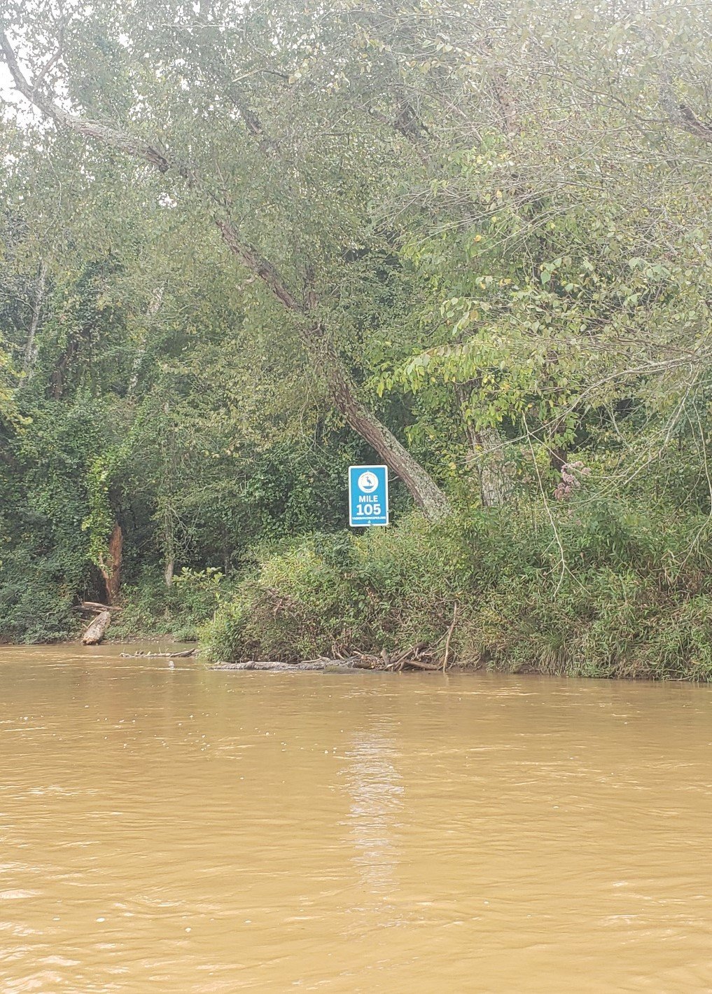
September 9 – Yadkin River at Pilot Mountain State Park at Yadkin River State Trail Mile Marker #105 at spot where September 5 photo was taken. What a difference a little rain and a few days make.

September 12 – Aerial photo of the mighty, muddy Yadkin River at the Davie/Davidson County line.

September 12 – The Yadkin flowing past the Yadkin River Park in Davidson County and under the Wil-Cox Bridge and I-85 carrying its sediment and nutrient load to High Rock Lake and beyond. Note the clearer “backwater” in the bottom lefthand corner.
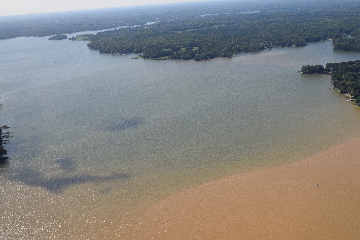
September 12 – Sediment plume from the previous week reaching the middle of High Rock Lake carrying its load of nutrients and bacteria.

September 12 – View of the sediment plume on HRL from another angle.

September 12 – View of High Rock Dam. Although the Lake above is clear, sediments carrying nutrients are passing below through the dam gates to Tuckertown Reservoir and Badin Lake.

September 12 – Excessive nutrients contribute to potentially Harmful Algal Blooms or “HABs,” which can produce toxins that are harmful to humans and animals. This is a lyngbya wollei or “black algae” bloom that covers hundreds of acres of Tuckertown and Badin.
Despite its reputation as a “brown river that’s too thin to plow and too thick to drink,” the Yadkin does and can run clear if measures are put in place to reduce nonpoint source pollution from agricultural runoff, land clearing, forestry operations and urban stormwater. YRK is advocating for the strongest possible rules to be developed through the NC Department of Environmental Quality’s High Rock Lake Nutrient Management Strategy. Specifically, YRK is calling for expanded stream/river buffer requirements and increased investment in stormwater management control measures. Click here to learn more about our recommendations for a cleaner Yadkin River.