Edgar Miller- Riverkeeper and Executive Director
An unseasonably and unusually intense winter thunderstorm on January 10 brought rainfalls levels of three to four inches to the Northwest and Central Piedmont in a matter of several hours leading to widespread flooding throughout the watershed on January 11. The Yadkin crested at just over 25’ on January 11 at the Yadkin College US Geologic Survey stream gauge near the Highway 64 bridge as it crosses the River between Davidson and Davie Counties. The River rose almost 24 feet in 24 hours and spilled out of its banks.
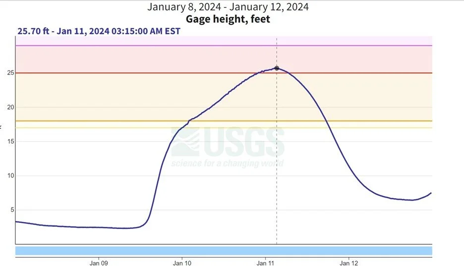
US Geological Survey Stream Gauge at Yadkin College reading on January 11 at 3:15 AM indicating the River is just above “Moderate” flood stage (25’).
Once again, the River’s floodplains did their job, absorbing a tremendous volume of water in a short period of time and limiting injuries to humans and property damage.

Flood waters breech the River’s forested buffer brining sediment and nutrient pollution into the River from nearby agricultural fields recently fertilized with chicken litter.
Protecting forested stream buffers, wetlands and floodplains along the Yadkin and its tributaries is paramount to protecting the future use of the River for drinking and recreation.

A closer view shows the breech right across from Davidson Water’s raw water intake and pump station.
Water plant operators typically take measures to prevent contamination from entering intake values during flood events. However, there was concern expressed about the pump station being in danger of flooding.

After the storm, shortly folllowing the River cresting, Davidson Water reservoir and pump station on January 11. Safe from the River’s flood waters.

Floodwaters breeched the Davidson Water Reservoirs in November 2020.
Extensive flooding throughout the watershed also resulted in numerous sewer overflows spilling tens of thousands of gallons of raw sewage into the River and its overwhelmed tributaries. With scientist predicting more frequent and intense storms, we can expect more flooding in the future.
To improve the resliency of the Yadkin River watershed and reduce the negative impacts on water quality resulting from increased flooding in the face of climate change, we must redouble our efforts to protect the River’s forested stream buffers, headwaters streams (not just those in the mountains), wetlands and floodplains. We must rebuild out wastewater infrastructure to survive increased flooding and get sewer lines out of the floodplains. Urban communties must invest in more effective stormwater control measures to handle greater volumes of water resulting from increased development and more paved surfaces. Farmers must implement more best management practices to reduce agricultural runoff.
This summer, residents of the Yadkin River watershed will have an historic opportunity to comment on state rules that will do just that, and reduce the amount of sediment and nutrient pollution going into the Yadkin and its lakes and tributaries. The Yadkin is the source of drinking water for more than 1 million North Carolinans and provides endless recreational opporutnities. Let’s make sure we do the right thing now to ensure it’s there for future generations.

Floodwaters near Highway 64 Bridge between Davidson and Davie County.

Flooded Yadkin River State Trail access at Highway 64.